
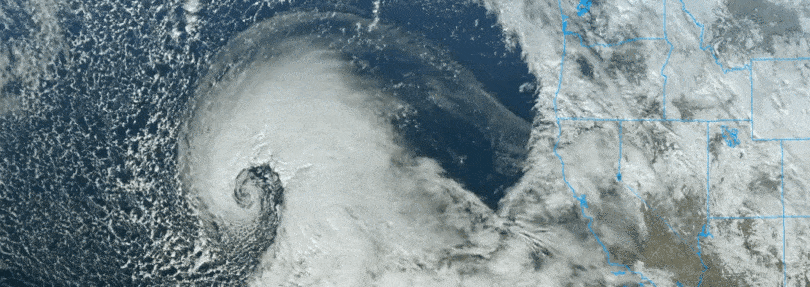
The bomb cyclone tapped into abundant tropical moisture in the Pacific Ocean, creating a strong Pineapple Express-type atmospheric river carrying significant amounts of moisture from near Hawaii to California.
RELATED: Pope Benedict XVI, Stern Defender Of Conservative Catholic Identity, Dead At Age 95
SAN FRANCISCO – A powerful double whammy of an atmospheric river and bomb cyclone is drenching California again Wednesday, dropping several inches of rain on a region that has struggled to wring out from an onslaught of winter storms and creating a widespread risk of flooding, mudslides and power outages in what some forecasters are suggesting will become one of the most impactful storms to strike the state in years.
California Gov. Gavin Newsom’s office declared a state of emergency Wednesday and said their storm response offices are at their highest emergency level.

The Sacramento Fire Department propositioned water rescue teams before the rain actually fell in earnest. California just hasn’t been used to this for probably the last 20-30 years. We’re moving through, the big thing we’re doing with our equipment that we’re asking to come in, we have a swift water team that’s pre-positioned here in the city of Sacramento.
“California just hasn’t been used to this for probably the last 20-30 years,” said fire captain Keith Wade. “We’re moving through, the big thing we’re doing with our equipment that we’re asking to come in, we have a swift water team that’s prepositioned here in the city of Sacramento.”
RELATED: How long will Andrew Tate and his brother be detained for in Romania?
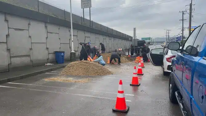
Coordination efforts are underway by the state’s emergency operations center to set up sandbagging locations and shelters and deploy ambulance strike teams. “We anticipate this may be one of the most challenging storms in California,” officials said.
Mandatory evacuations were ordered for several neighborhoods that face a high risk of flooding. Police across northern California continue to evacuate homes as more rain falls.
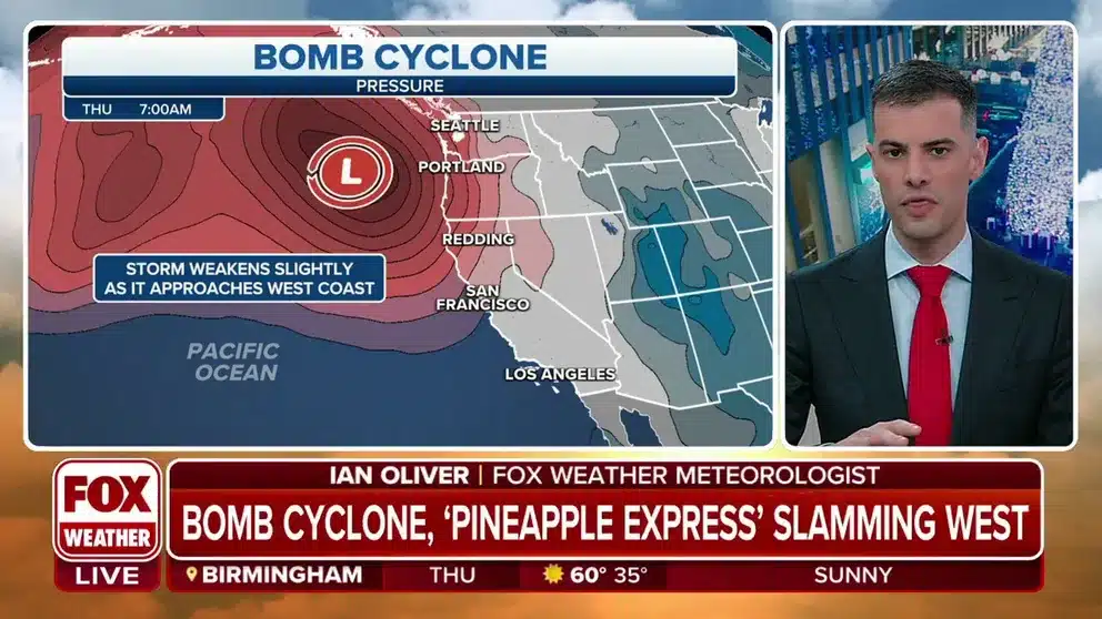
Storm becomes ‘bomb cyclone’
The storm underwent rapid development off the California coast over the past 36 hours, becoming what meteorologists refer to as a bomb cyclone. As the storm intensified, it tapped into abundant tropical moisture available in the Pacific Ocean, creating a reasonably strong “atmospheric river” carrying copious amounts of moisture from Hawaii to California.
RELATED: 5 chilling details about Nathan and Krystal Maddox’s murders
WHAT DOES A ‘CATEGORY 5’ ATMOSPHERIC RIVER MEAN? SCALE AIMS TO RATE NATURE’S LARGEST SOAKERS
“Basically, an (atmospheric river) is a river in the sky of water vapor, and when it hits the mountains, (the moisture) is forced up over the mountains,” Marty Ralph, Director of the Center for Western Weather and Water Extremes, told FOX Weather. “That upward motion causes clouds and precipitation to form, and the faster the flow of air and water vapor is hitting the mountains, the faster the rain is falling, so you get more and more rain with the stronger ARs hitting the mountains.”
This specific type of atmospheric river, known as the “Pineapple Express” in a nod to the storm’s fuel source due to its Hawaiian origins, is set to bring significant moisture to California. Think of this as a narrow pipeline of moisture that originates in the tropics.
RELATED: Crypto Heists: Over $3 Billion Stolen in Eight Biggest Crypto’s companies.
WHAT IS A PINEAPPLE EXPRESS?
The significant threat of widespread flooding from an atmospheric river
Flood watches span much of the state, from near the Oregon-California border to just north of the Los Angeles area.

Of particular concern are the potential for debris and mudflows where heavy rain falls in areas burned by major wildfires in the state over the past few years.
WIDESPREAD WESTERN WILDFIRES PLUS WINTER WEATHER: A DANGEROUS SETUP FOR DEADLY DEBRIS FLOWS

Some areas along the Northern and Central California coast could see 5 to 8 inches of rain, while farther inland, rainfall totals in the mountains and their foothills could approach 8 to 12 inches in some spots.
RELATED: Gervonta Davis arrested in Florida for domestic violence
HOW TO WATCH FOX WEATHER
The San Francisco Bay Area, which saw its second-wettest day on New Year’s Eve, could see an additional 2 to. 5 inches of rain with locally higher amounts.
Even the Los Angeles area could have 2 to 4 inches of rain – with 4-8 inches of rain possible in the Southern California mountains – by the time the storm system moves through.

Since atmospheric rivers have been dropping near-record amounts of rain across California since before the Christmas holiday – as much as 5 to 12 inches – the additional water will have nowhere to go. As a result, numerous instances of flash flooding and mudslides are expected.
Considerable and life-threatening flooding is especially possible along the northern and central California coast. Rivers across the state are forecast to rise into flood stage.
Santa Cruz County, which sits along the central California coast, has already declared a local state of emergency as the county already suffered more than $10 million in damage from last weekend’s atmospheric river storm.
ATMOSPHERIC RIVER TURNS DEADLY AS IT SLAMS CALIFORNIA WITH FLOODING, MUDSLIDES

‘Likely loss of human life’ from atmospheric river impacts
Meanwhile, the bomb cyclone will create a tremendous difference in pressure across regions, leading to widespread high-wind events that could last for several hours.
RELATED: Jordan Douglas Krah arrested following racist San Ramon Rant on Tiktok
High Wind warnings span much of Central California into Thursday morning for gusts between 50 and 60 mph in the San Francisco Bay Area, 60- to 70-mph gusts in the Sacramento Valley and 65- to 70-mph gusts possible along the coastal and mountainous regions. In Southern California, gusts from 50- to 70 mph are likely in the mountains and central coastal regions.
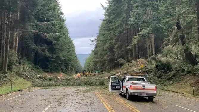
Already a gust reached 66 mph in Eureka and an 18-mile stretch of Highway 101 is closed in Humboldt County due to multiple downed trees.
Wind reports are coming in exceeding 90 mph in areas.

A few strong thunderstorms are possible in the region Wednesday night that could bring sudden localized damaging wind gusts.

With heavily saturated grounds and hours of such wind speeds, widespread power outages are likely. “Customers are strongly urged to prepare for potential extended outages,” Pacific Gas & Electric officials warned.

WHAT IS AN ATMOSPHERIC RIVER? EARTH’S LARGEST FRESHWATER RIVERS ARE IN THE SKY

The current storm combined with the saturated soils from previous storms has emergency officials bracing for widespread damage from flooding and mudslides.
National Weather Service forecasters in San Francisco were not mincing words about the upcoming threat.
RELATED: Baseless Reports Claim Kanye West Has Been ‘missing’ For Weeks
“To put it simply, this will likely be one of the most impactful systems on a widespread scale that this meteorologist has seen in a long while,” an NWS meteorologist in San Francisco wrote in a forecast discussion Monday evening. “The impacts will include widespread flooding, roads washing out, hillside collapsing, trees down (potentially full groves), widespread power outages, immediate disruption to commerce, and the worst of all, likely loss of human life. This is truly a brutal system that we are looking at and needs to be taken seriously.”
In addition, forecasters are warning about coastal flooding along the San Francisco peninsula that would flood parking lots and coastal roads.
An atmospheric river once again brings snow measured in feet to Sierra Nevada
While rain will fall at the lower elevations across the West, as you get higher in elevation, snow is expected.
Up in the mountains, dangerous travel conditions are developing and will continue through Thursday night as extremely heavy snow rates greater than 3 inches per hour are near certain 5,000 feet.
This will lead to dangerous, if not impossible, travel conditions. In total, an additional 1-4 feet of snow is expected across the Sierra Nevada. In Southern California, the highest peaks of the mountains will pick up 1-2 feet.
Winter Storm Warnings are in effect across the Sierra Nevada for not only heavy snows but damaging winds gusting to 55-70 mph along the higher peaks with gusts reaching 85 mph on the highest peaks.

There is no (sun)light at the end of the tunnel yet
This latest storm will eventually push through by late Thursday or early Friday, but there is scant hope for drier weather in the Golden State anytime soon.

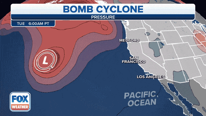
Another atmospheric river will blast the state this weekend and then yet another powerful one is likely next Tuesday-Wednesday, according to the FOX Forecast Center. Each will bring a renewed round of dangerous flooding.
Over the next week, as much as 20 inches of rain may fall in the northern parts of the state.
RELATED: Crypto Heists: Over $3 Billion Stolen in Eight Biggest Crypto’s companies.
“The cumulative effect of the repeated rounds of moderate to heavy rain will lead to the potential for more widespread flooding with increasingly severe impacts,” the National Weather Service in Sacramento said in their discussion Wednesday morning.
Fellow NWS meteorologists in San Francisco added in their forecast discussion: “The message to convey is resiliency as this is not a ‘one and done’ storm.”
Despite relentless atmospheric rivers, drought still factor in California
Several inches of rain in the forecast on top of what’s already fallen this winter is surely appreciated in a region mired in a yearslong drought. While every drop helps, the area has a long way to go.
“At this point in time, we still have another four or five months in our snow season and in our typical rainy season,” Andrew Schwartz, lead scientist at the Central Sierra Snow Lab, said last week. “That means that while we’re kind of scoring the touchdown in the first quarter of the game. Right now, we still have three-quarters left, and there’s a lot that can happen.”
Schwartz said last year’s winter season started well with a record-breaking December mountain snowfall.
RELATED: Greta Thunberg humiliates Andrew Tate ‘small d**k energy’
“But January through March kind of shut off, and we didn’t see as much precipitation come through in that period as we would have wanted,” he said.

Even an average snowfall season wouldn’t be enough to get the region out of drought.
“At this point in time, we really need about an extra winter’s worth of precipitation,” Schwartz said. “So, it’s not going to happen in one year. At a minimum, we’re probably looking at three to four of above average before we can really talk about getting out of the drought.”
In an average season, the lab sees 30 feet of snow. An extra season’s worth of snow would mean 60 feet in one year. He said it is a “high task to try to take on.”